
Your surveying consultancy with 18 years experience.


Built in British Columbia. Now serving Sydney, the Illawarra and the Hunter.
BMH Spatial was founded by Ben Hall in British Columbia, Canada in 2020. The business developed predominantly working embedded in teams delivering capital infrastructure projects for institutional clients before relocating to Australia in 2026. Ben brings 18 years of experience surveying across the Australian and Canadian construction and mining industries. Now based in Cronulla, BMH Spatial serves clients across Sydney, the Illawarra and the Hunter.
The move brings BMH Spatial and Ben home to Australia with a wealth of international experience, a fresh perspective on Australia’s construction industry, and the discipline that comes from working in two of the world's most technically demanding construction industries.
Ben understands that his clients deserve accurate data and a straightforward experience. Quality spatial data delivered on time is what BMH Spatial is built on.
We work with institutional clients, infrastructure owners, engineers and developers who need accurate spatial data across the full project lifecycle. From feasibility and design, throughout construction, to handover, and on to maintenance and improvement. When disaster strikes, we also support emergency response and recovery efforts, providing rapid spatial data to help communities and agencies assess damage, plan reconstruction, and rebuild with confidence.
Whatever the project, big or small, the standard is the same: work we're proud to put our name on.
What we do
BMH Spatial is a surveying and spatial consultancy with 18 years of experience across the Canadian and Australian construction industries. The services below cover the work we are set up to deliver. If you are not sure which applies to your project, contact us and we will work it out with you.

Topographic surveys
Accurate ground surface data capturing the natural and man-made features of a site. Used by engineers, architects and planners as the foundation for design and development applications.

Construction and engineering surveys and setout
Precise positioning of structures, infrastructure and civil works during construction. We work directly with engineers to ensure what is built matches what was designed, on time and in specification.

Hydrographic surveys
Underwater terrain mapping of rivers, harbours, lakes and coastal environments. Used for dredging, infrastructure planning, environmental assessments and maritime works.

Deformation monitoring
Ongoing measurement of ground movement shifts over time. Critical for projects where subsidence, settlement or earth movement poses a risk to nearby assets, infrastructure or the public.
Structural monitoring
High-precision monitoring of bridges, retaining walls, tunnels and buildings during and after construction. We track movement and report against agreed tolerances so engineers can act on quality data.

UAV / RPA surveys
Drone-based aerial data capture through lidar and photogrammetry for sites where speed, coverage, safety, or access makes traditional methods impractical. Outputs include point clouds, orthophotos, surface models and derived traditional deliveries (coded points and strings) suitable for engineering and planning workflows with the benefit of reducing engineering team site visits due to data fidelity.

Owner's representative construction supervision
Independent eyes on site for clients who need someone looking after their interests during construction. We attend on your behalf, review progress, negotiate disputes, and flag issues before they become costly.

QC / QA surveys
Survey-based verification that construction works meet the required specifications and tolerances. Commonly required for civil infrastructure, road works and government projects where sign-off depends on documented compliance.

CAD services
Production of survey drawings, plans and digital terrain models delivered in industry common formats.

Quantity calculation and payment verification
Independent quantity calculations such as volumes, areas, lengths, and counts from survey data. Used to verify contractor claims, progress payments, and bill of quantities. Commonly used by project owners to verify progress and contractors for their progress claim submissions.
Our work

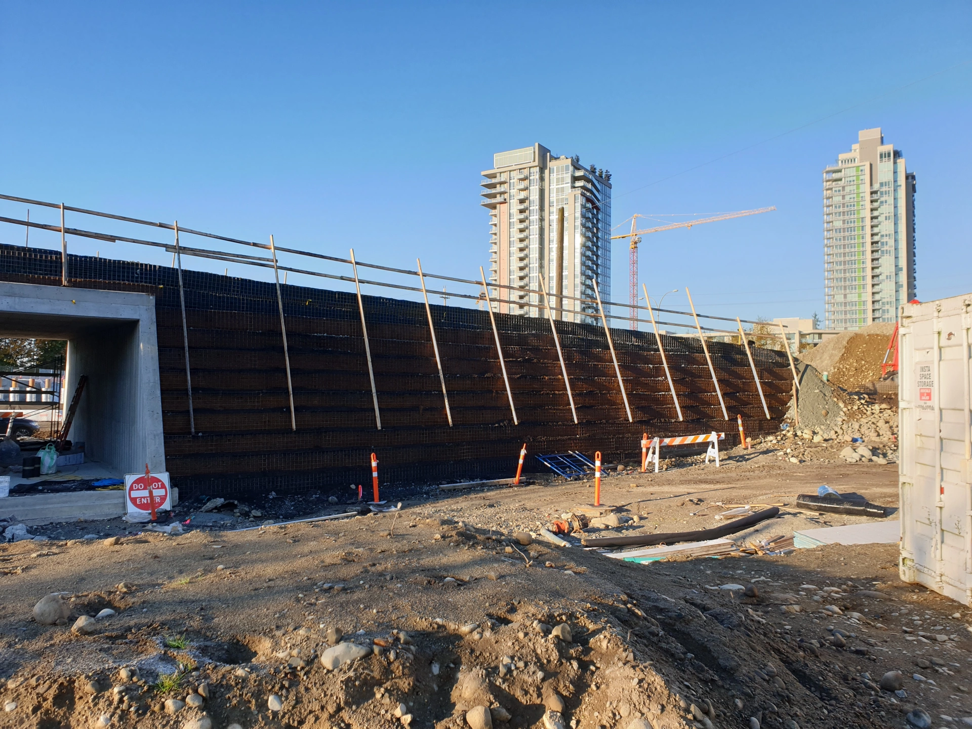
Highway 7 266th to 287th Street Widening Project supervision
BMH Spatial was engaged as the owners representative surveyor for the project which aimed to increase capacity by providing two travel lanes in each direction (four lanes total), reduce congestion, and improve safety. The scope included construction of new walls, re-aligning existing roadways, sensitive habitat creeks and 3rd party utilities.

264th Street to Highway 11 Highway 1 FVH1CI
BMH Spatial was engaged for structural survey supervision on the Bradner Road Overpasses on the Fraser Valley Highway 1 Corridor Improvement Program as the owners representative surveyor. The scope consisted of 2 phase built overpasses, associated MSE retaining walls and the demolition of 2 existing structures.

216th Street to 264th Street Highway 1 FVH1CI
BMH Spatial was engaged for structural survey supervision on the Glover Road Overpass on the Fraser Valley Highway 1 Corridor Improvement Program as the owners representative surveyor. The scope consisted of 1 overpass and associated MSE and CIP retaining walls.

264th Street to Highway 11 Highway 1 advanced works
BMH Spatial was engaged as the owners representative surveyor for the advanced works to de-risk the upcoming Fraser Valley Highway 1 Corridor Improvement Program projects. In scope were earthworks, walls, pre-load, and pre-locates. The majority of the surveying was undertaken and successfully delivered using drone/RPA lidar to overcome the safety denied nature of the project.

Lower Lynn Connectivity Improvements 2 Project supervision
BMH Spatial was engaged as the owners representative surveyor with works in scope including the rehab of the existing Lynn Creek bridge and construction of 4 new bridges, multiple walls, on and offramps, re-aligning existing roadways, realignment of sensitive habitat creeks and realignment of 3rd party utilities.

Highway 11 Disaster Response
Following the December 2021 atmospheric river event a segment of Highway 11 in Abbotsford experienced major deformation and was subsequently shut indefinitely closing down a major commercial artery in the Lower Mainland. BMH Spatial was engaged to monitor the deformation initially to determine the magnitude of the movement, then during partial reopening determine ongoing stability to ensure safety for the travelling public. BMH Spatial was then engaged for the phased reconstruction including the removal of EPS fill, construction of sheet retaining wall, soil mixing, and re-paving.
Vancouver Island Disaster Response
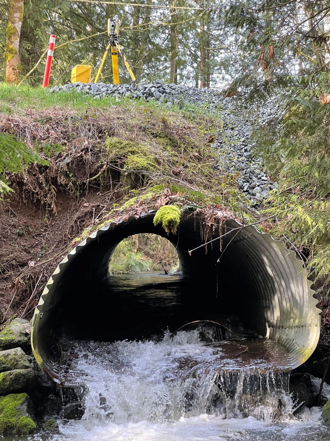
Following the December 2021 atmospheric river event many segments of the Islands road network experienced various failures attributed to aging, undersized or poorly maintained infrastructure. BMH Spatial was engaged to undertake topographic detail surveys for preliminary designs to remedy the failures experienced.

Highway 28 Cervus Creek Bridge and Elk River Bridge
BMH Spatial was engaged predominantly offsite for construction support and supervision during the replacement of 2 bridges and associated approaches, walls, and earthworks along Highway 28. Deliverables included quantity calculations progress, final, calculations, reductions from engineering drawings, layout data for field crews and survey ascon.

Highway 99 at Alice Lake Road
BMH Spatial was engaged to undertake topographic detail surveys for preliminary designs to remedy safety issues at the intersection of Highway 99 at Alice Lake Road due to increased traffic volume from tourism and population growth. Largely traditionally delivered except the asphalt pavement which was laser scanned removing the need to hire traffic control - usually an additional expense.
Get in touch
Please supply your email and/or another preferred contact method and a brief description of your job or project and we will reach out to discuss how we can best serve your needs.